Annapolis National Cemetery


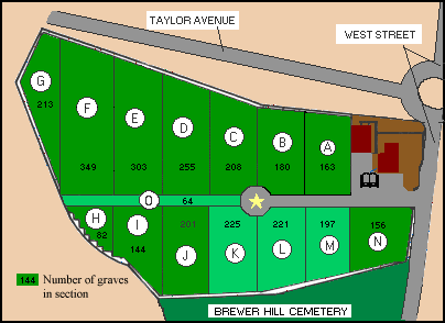
General site map

Annapolis National Cemetery
Primary cataloging, which began on August 9, 1998, has been completed. However, while I was 'wandering about' I noted that several tombstones have inscriptions on their reverse face which remain to be cataloged.
The Annapolis National Cemetery comprises 4.125 acres of gently rolling hillsides. Now located well within the incorporated city limits, the cemetery was once a five-minute carriage ride outside the city line.
As each section of the cemetery is mapped and coded, the lettered section of the map above is clickable and will yield a larger map of that section.
Annapolis National Cemetery